Are you looking for Ba Be National Park map or Bac Kan map? This site provides with the map of Bac Kan (or Bac Can) province and the map of Ba Be lake.
Bac Can is a mountainous province located in the interior of the Northeast of Vietnam. There are many high mountains (more than 1,300m high) such as Nam Khieu Thuong mountain chain and Hoa Son mountain.
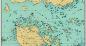
Bac Kan is potential for developing adventure and eco-tourism. You can choose a tour to Ba Be Lake which is the largest lake of the North of Vietnam. The lake is surrounded by limestone and schist. Ba Be national park is also included in this destination with an area of 23,340 hectares with 417 species of plants and 299 species of vertebrate animals. Other adventures are also available including tour to Kim Hy reserves nature park; tour to nature caves such as Nang Tien, Puong cave, Ba Cua cave, Son Duong cave. Besides that, Bac Can also has many famous historical places such as Historic Security Area, Phu Thong, Giang pass etc.
Ba Be Lake Map

Map of villages in and around Ba Be Lake

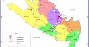
Map of Bac Kan Province

Map of Bac Kan Province made by Vietnam National Administration of tourism
“By Hoang Anh Vu“